I’d been over the Robbins Bridge a few times when the Sabin Dam was first being dismantled, but I hadn’t been back in a while.

With Airport Road so clogged with traffic this summer, I’ve begun taking Hammond to Keystone to Cass to get to the other side of town. I had my camera with me, so on one of those trips, I decided to stop in the parking lot just above the Robbins Bridge and take some pictures.

As part of the Boardman River Dams Ecosystem Restoration Project, three dams were set to be removed. In 2012 the Brown Dam was removed; in 2017, the Boardman Dam was removed. In the fall of 2018, the Sabin Dam and Powerhouse were removed. The purpose of the project was to find the natural river bottom and divert the Boardman back to its original course.

With that process completed, fish passage would be restored to Grand Traverse Bay. Additionally, there would be reestablished wetlands as well as native plant areas. Wood and sediment would also be able to move freely through the river system. The new river will also be able to better handle the high water that has come with climate change. It will take three to five years for the whole ecosystem to return to life.

As I watched the new river flowing under and beyond the bridge, I was fascinated by the whole project, which was completed through a partnership with the Army Corp of Engineers and the Grand Traverse Band. From my perspective, I saw that the river had some fast-flowing rapids and wondered if kayakers were already traveling the new river.

In researching this topic, one part that especially interested me was an entry in the Grand Traverse Journal that told the story of Jack Robbins, who owned a farm in the Boardman Valley on Cass Road. The whole river restoration effort was aided by a historical map that Robbins had tucked away in his farmhouse. Robbins shared the map with the Army Corps of Engineers, and it was instrumental in helping them return the river to its original channel and restore the banks. Surely, that is why this bridge has been named the Robbins Bridge.
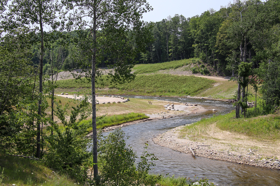
I stood at the far end of the bridge and watched the river flow its historic, natural channel after being impounded for over a hundred years. It was an amazing scene to watch, but the story doesn’t end here.

In the past, any mucky sediment was held back and managed by the dam. Now, with the river flowing freely, larger amounts of sediment can travel down the river, especially in this early phase of the restoration. One such sediment disbursement contributed to the formation of a delta at the South end of Boardman Lake. At first, this caused some concern, but the rush of sediment is expected to settle down and create a new wetland complex. This interface between the river and the lake over time will create new fish and wildlife habitats.

Already, there have been sightings of a Snowy Egret, a Great Blue Heron, and some Green Herons at the new Boardman Lake Delta. I missed seeing and photographing those beauties, but the morning I went, I got to see a turtle and a couple of mallards. I'm sure I will see more species in the future.
A beautiful and very interesting post, Karen! Thanks for sharing!
ReplyDeleteThanks, Jan. It was interesting to learn so much just from the act of crossing the bridge and taking some time to research the project.
ReplyDelete